Showing posts with label Activity. Show all posts

Thursday, September 20, 2012

Pirate Party

Our boat, under construction in Nick's front yard.
 Last week an email came through the Dissociates mailing list saying that Saturday was a special occasion. In honor of Talk Like A Pirate Day, a Pirate Party was going to be held out on Coconut Point. This wasn't going to be a stand around and drink in costume affair, it's one where you were expected to show up and build a boat to sail around Coconut point to an island in the neighboring lagoon and back. Not to be denied the opportunity to build a watercraft and paddle it around, I showed up at my friend Nick's house early and we began constructing our vessel. We bagged two of the Coast Guard kayaks and lashed them together, we built platforms for sitting on out of surf boards and an old shipping pallet and soon were ready to roll. We hoped to have time to build a mast for a sail or a coconut launcher for boarding actions, but ran out of nails prior to either of those ideas coming to life. We did manage to construct a solid raft that eliminated the play that I worried would doom any on the water momentum.

The crew getting ready to undertake our voyage.
Next we recruited a crew. Picking up two able-bodied men, Jorge and Zach to man the paddles. With our compliment of sailors in place we set about getting our boat in the water. Carrying the boat down to the launch point we were still a little concerned about the stability, but we tightened up our lashings and got the SS Sea Bitch on the water and provisioned ourselves for the voyage. Jorge had the foresight to bring a large patio umbrella to the party. We skeptically added that to the boat's supplies. With as brezzy it was that afternoon, I didn't believe that we'd be able to open it or hold on to it when open, but we had the room, so what the hell.

Jorge paddling.
Our first leg of the voyage we were moving perpendicular to the wind heading eastward along the shore of Coconut point. The current was with us and we made good time and even managed to enjoy a beer while we made our way to the end of the Point and our turn northwards into the Pala Lagoon. The boat paddled smoothly and we ended up passing a few of the kayakers who showed up to witness the spectacle. Once we got the boat turned to the north, we decided it was time to try and use the umbrella as a sail. I stowed my paddled and pulled out the massive wooden umbrella and set about opening it up.

Our umbrella sail in action. 
With the sail unferruled we quickly caught the wind and plunged towards our next destination, Coconut Island in the Pala Lagoon. It's a tiny clump of dirt in the middle of stagnant lagoon. It's defining feature is a single palm tree that is struggling to hold onto one edge of the island. Sara's previously kayaked out to it, but made the mistake of going at low tide, so the approach to the island was through knee deep mud, dragging the kayak behind. Thankfully, this voyage was at high tide and it was smooth sailing the whole way in. Turns out our home-made catamaran was an excellent downwind sailing ship. We flew towards the island with little more than a some rudder work by Jorge in the rear of the boat.


Party on Coconut Island. 
 Once we reach out destination it was time to tie up and enjoy some grog in true pirate fashion. We passed around beers from our cooler and relaxed on the tiny piece of land in the middle of the Pala. We waited for the fleet of kayakers and aspiring pirates to float their way in to the island. Slowly, the armada started pulling up to the island and tying onto our boat. Which may not have been the best idea, as we were only tied onto an inch in diameter branch on a dessicated little shrub.
Having some refreshment on the deck of our boat.


The other pirates paddle their way in.

Nick enjoying a Corona.

The after party.
Eventually most of the other people on the water made their way to the little island. As land to stand on started to be at a premium, some of us resorted to hanging out and watching the sunset from our boats. The sun started to dip its way past the horizon, but we still had a few stragglers left to make it to the island.

The last boat in was optimistically built out of a solar panel with an electric motor attached. The cloud cover and the lateness in the day conspired to force them to paddle the whole way. They made it to the Island with the pirate flag flying and half a bottle of rum. Excellent work on their part.


The next leg in the journey was to get back to Coconut point. We launched from Coconut Island and tried out our umbrella sail, this time running east, perpendicular to the wind. Turns out our little catamaran tracks well without a dagger board. We were able to catch the wind and track true going across the wind. This made our trip back to Coconut point an easy stroll compared to the rest of the fleet that was stuck paddling their way back through the early evening light.

Once we were back to land, we broke down our boats and carried them back to the yards we got the parts from. To finish off the evening we had Tutuila's most popular cover band, Three Leg Dog playing on a balcony and enjoyed some beers at Kelly and Alden's place at Coconut Point. Piracy won this event.

Monday, March 5, 2012

Northside Paddling Adventure

In early January, we opted to join a large group of our friends for a kayak adventure. We met up at Coconut Point, everyone was dragging ass (as usual...), but eventually we got loaded up and going.

We headed out to Fagasa, one of the few villages on

the north side of Tutuila. We pulled up to the small
boat ramp that one of the National Park marine biologists (who was leading the trip) regularly launches from. He introduced us to the matai, in Samoan chief, who lives next to the boat ramp. He was lounging in his lava lava and happy to meet us, since we are friends with the National Park guy, who he considers family. He offered to watch our cars if we parked next to his house. We moved the cars, unloaded and launched.

The paddle out was great, there were some large swells in the open water, once we got outside the mouth of Fagasa Bay. It was a beautiful way to see the island and it was great to out with a large group exploring the otherwise inaccessible North side of our island.

We paddled several coves to the west and ended up landing in Sita Bay. The route into the Bay was a little dicey.


To reach the beach, we needed to paddle in the ava, which is a narrow channel in the reef. The channel mainly serves as the drain for the basin of water that builds up behind the fringe reef as waves break over the reef. As a result, the ava has a strong outward current. This is further compounded by the waves breaking over the shallow reef. This is challenging, more so if you're not comfortable in a kayak. A number of members of our trip were rookie kayakers, so we had varying levels of panic following our paddle up the gullet of the ava.

Sita Bay was a cool place to explore. Our Samoa friend caught several coconut crabs and taught a few of us how to identify their burrows and how to grab them so as not to lose a finger to their claws that can crack coconut shells.


Sara did her usual seashell hunt and came away with some great shells, which is a great advantage to infrequently visited shores.


After a little rain, we launched back out to sea and continued west to Fagafue Bay. Most of our group landed here, but Sara and a prosecutor from our office did not want to brave another ava, so we decided to paddle back to our starting point. It was a beautiful day and stoked my fire to spend so more time kayaking while we're here.

Tuesday, October 25, 2011

Outrigger Regatta

After being off paddling for a few weeks for our trip back to the mainland, it was nice to get back into the routine of outrigger canoe again. Last weekend Sara and I were able to put some of that experience to work at the Moso'oi Festival Outrigger Regatta.

It was a large group of paddlers that came out for the canoe race. Between adult and youth paddlers there were easily over one-hundred participants. After registering and getting our gift bags we were randomly assigned to teams.

The weather was off and on raining, so some of the paddles were wet and some were sunny, luck of the draw. Each race consisted of four boats per heat. It was actually two races going on at once, the 2 heavier boats were facing off against each other and the two lighter boats doing the same. So in theory you could come in 3rd place out of four and still potentially win your race.

The actual racing for Sara and I was not that interesting. Neither of our teams preformed well, my team was eliminated after two rounds (of double elimination). Sara made it one round further, but were losing when one of the boats they were not racing against flipped. I hadn't yet seen a boat flip and was surprised how quickly it happened. Once the ama started lifting, the momentum quickly spun the boat over. Before you blinked the boat was over and the competitors and their paddles started bobbing to the surface around the boat. Sara's boat turned around and assisted the flipped canoe with flipping it back over and bailing the body of the canoe. The post flip mop up process took about fifteen minutes, which slowed the pace of the regatta.

With several heats still to go, Sara and I decided not to stick around until the end. We passed our raffle ticket off to a friend who was spectating and headed home and called it an afternoon. We weren't sure what to make the next day when there was a picture posted on Facebook with us tagged, talking about our new stove. Apparently the ticket we passed along won the grand prize for the raffle, a propane stove. Having a perfectly good electric range, we're not sure what we're going to do with our race day prize. My vote is having the best car camping kitchen on island.

Friday, October 21, 2011

Samoa Weekend

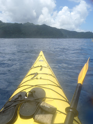
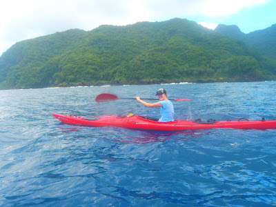
The weekend immediately following our mainland trip we had another off-island excursion planned to (Western) Samoa. Our Australian friends need to leave the Territory of American Samoa every 60 days for visa reasons, so they are regular travelers to independent Samoa. We figured they would be perfect tour guides for our first trip over to the closest major island to Tutuila.

With our itinerary in place we packed ourselves onto an 18 person flight. Seats were assigned based on weight. Sara and I were lucky enough to get seats together in the back of the plane. When they closed the door, there was a noticeable gap the whole way around the door. This was definitely not a mainland commercial flight. The flight was less than an hour by propeller plane, we didn't quite reach 5000 feet in elevation and also got some excellent views of both Tutuila when we were taking off and of Savai'i when we landed.

We were greeted on the ground by the slackest customs I have ever had the pleasure of being ushered through and were soon out in the sprawling metropolis of Apia, Samoa. Two of our party who had headed out earlier in the afternoon met us with a rented 16 passenger van and we were soon perched in our room at the Amanake Hotel. After a little time to relax and settle in we were off by taxi to enjoy the fine dining options of Apia.


We did dinner at an Italian food restaurant named Paddles. Dinner was some pasta on a lovely deck overlooking the harbor. The eight of us on the trip settled down to a lovely dinner of wonderfully prepared food, that looked more like a dish that you would get at a restaurant back home on the mainland than the usual level of service and food prep we have come to expect in American Samoa. Overall, a lovely evening spent out on the town.

Once the restaurant was given over to the night club we caught a cab back to our hotel and managed to catch the end portion of the France vs. England match of the Rugby World Cup in the hotel bar. We then managed to drink for too much on a patio and called it a night.

The next morning we piled into the van and headed out for some breakfast at the Sydney Cafe. Downtown Apia was packed with people doing their holiday shopping for White Sunday, as a result our driver, Aussie Ben, had to resort to dropping us off on a corner and driving around for 25 minutes to find a place to park, more like San Francisco than Samoa.

We had a nice breakfast on the patio with the constant bustle of people doing their holiday shopping. Afterwards we went and explored the traditional crafts market in Apia. Sara and I ran into two people that we had connections to at the market. The first was a woman who was selling beautifully carved and stained 'ava bowls. When we mentioned that we were living in American Samoa she told us about her tall pregnant friend who lives in American Samoa. When we asked if she was named Nikki, the lady responded with a resounding yes, turns out she was talking about the civil division chief in Sara and I's office. The other person we ran into was one of the Customs Officers that Sara and I have scheduled as a witness in a tax case. Even 5,000 miles from home you can run into all sorts of unexpected people you know.

We then headed to the store to stock up on supplies of beer and food for heading out to the far side of the island. We then took the road across the middle of the island. Along the way we stopped at the first of several waterfalls. I'm not about to try and pronounce the name, but anything spelled Papapapaitai deserves to be shared. The waterfalls were down to a trickle. Turns out that Western Samoa was experiencing the same drought that had been plaguing American Samoa for the past few months.

The next waterfall we stopped off at was even more of a disappointment. After a short hike in
we did not even get a trickle. The waterfall was completely dry. Instead all we got a drying out pond and the empty watercourse of a waterfall and river. It was an amusing stop and provided plenty of ammunition to rib our tour guide. So far for the day we were 0 for 2 in the tourist spots. It had to go up from here, and it did.

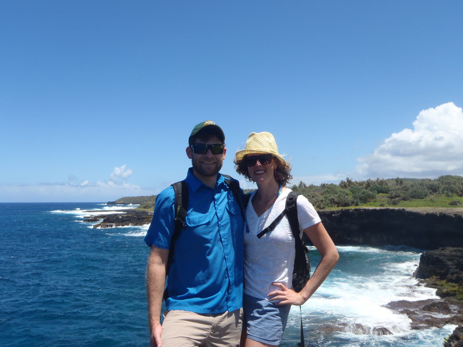
The next destination on our schedule was the Sua Trench. Not having done any research, I didn't have high expectations for a "trench." Thankfully I was way off. The Sua Trench is a volcanic sink hole that is fed by ocean water. The hole is about 100 feet from the rim to the water, but only about 5 to 10 feet deep in the water. It made for a cool and unique swimming hole, once you made the long climb down a steep ladder.

There were also caves that connected the sink hole with the ladder to a neighboring sink hole. It was an easy swim over to other sink hole. The water in the sink holes also were subject to quite a bit of tidal and wave influence. Our guide had even considered bringing a dive tank to attempt to explore the narrow underwater passage that led back out into the ocean, but opted to try that on another trip when he wouldn't be carting his gear around in a van full of people and luggage.
We spent a few hours lounging on the deck attached to the ladder in, exploring the sink holes and caves and swimming around the Sua Trench. It was a beautiful spot and I'm eager to go visit it again. Alas, we did have more destinations to see on that Saturday, so we braved the climb out, dried off and piled back into the van to continue our journey.

Our next destination was the beach fales we'd be staying at that evening. They were along a beautiful stretch of white sandy beach (something we don't have quite enough of in American Samoa).

The beach fales epitomize the traditional notion of what life on a small island in the South Pacific is like. They are a quiet little cluster of open huts sprawled out on a lonely stretch of beach. The bathrooms are across the street, but traffic isn't much of an issue, we only saw a handful of cars crawl by in our two days at the fales. The things to do there were, hang out on the beach, hang out in the communal fale or take a walk. It was ideal, relaxing weekend away. We made the most of the time there with some cocktails and reading at a table in the main fale. We also hit it off with a couple living in New Zealand, she was a German and he was of Indian descent, through London. They were living in London and we were able to relax and talk about all the pressing issues presented by rooting for squads in the Rugby World Cup.

One of the highlights of the night spent at the beach spent at the beach fales was the fia fia dance show the staff of the fales put on after a large communal dinner. If our camera hadn't been low on batteries, I would have some great photos to share. The dancing involves some traditional Samoan elements and some that are an invention of the 20th Century. The most dramatic part is the fire knife dance, in which one of the performers lights a blade on fire and spins it around. Like I said, quite photogenic...

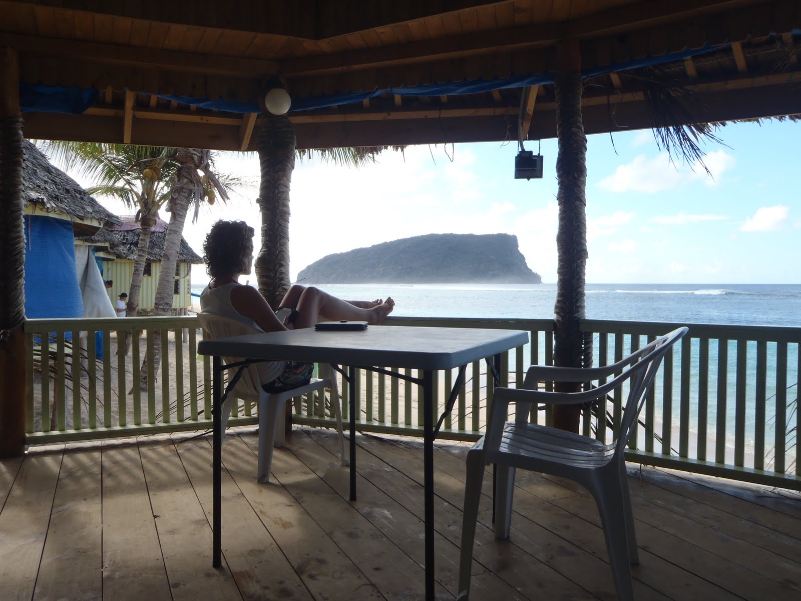
We had another communal breakfast and spent a portion of the morning relaxing and reading and then it was off to Virgin Cove. The Virgin Cove beach fales are on a remote stretch of coast. The next beach over is where the two seasons of Survivor were shot in Samoa. They'd wrapped up shooting the last season there a few months before our arrival. I know if the shoot had still been going on my mother would be despondent that we didn't try and sneak over and get ourselves on the air. Instead we relaxed on the beach, enjoyed the sandy beach and read in our fales.

The fales at Virgin Cove were much nicer than the ones at the first beach fales. In place of tarps these had mats woven out of palm fronds. Instead of the huts being stacked close together on a beach, the lodgings were spread out amongst a sandy thick of trees and brush. Crab trails arced across the stretches of sand not designated as trails. It really was a beautiful spot to spend an evening. The dinner was under an awning and we had a menu to order off of. Overall a delightful evening, but much mellower than the fia fia show and party atmosphere of the beach fales.

Once we checked out the next day we did a long lunch stop at a resort that was built on a pier in front of a fancy beach resort. As it had been for the whole trip, the food was excellent and we were all eager to get cocktails, which is generally a hell-ish experience involving syrupy sweet recipes and often none of the right ingredients in American Samoa.

The highlight of the lunch was jumping off the end of the pier once lunch and drinks were completed. The pier ends near a freshwater up welling in the reef. The surrounding reef is shallow, but the hole that the freshwater is pouring out of is deep and jumping distnce of the end of the pier's decking.

We spent the first part of our last afternoon in Samoa diving into a little hole in the ocean. Not a bad way to spend our first weekend back on the island...


Monday, September 19, 2011

Mt. Alava Through Hike


Previously, we climbed Mt. Alava along the ridge trail that starts on the east side of the ridge. Wanting to try to improve on the 7-mile out-and-back-hike, we decided to start the hike on the northeast side of the mountains and turn it into a through hike.

To do this we started at the trailhead that I had previously gone hiking along a loop through the National Park and for the Vatia Tide Pools. It"s a small turnout off the round inside the National Park with a little fale and enough room to park a few cars. From here we ran into a group of palagi who were headed down to the tide pools. We instead started taking the path up the hill.

The trail up the ridge is well maintained and makes for some easy hiking compare to most of what we have here in American Samoa. The National Park Service is good at maintenance and the trails see a relatively high amount of usage, so there's less overgrowth and underbrush to worry about on this trail.

Another nice feature of this trail is the first bit is through heavily canopied forest, but the trail rises fast and you quickly get up to the ridgeline and get to see some spectacular views looking out on the north-side of the island. The ridge is great for hiking you get breezes from all directions and it's some of only cool air you can get outside on this tropical island.

This shot is of Vatia Bay and the rock formation known as the cockscomb. The trail keeps climbing and soon you end up on the ridge that runs down the spine of the island, Pago Harbor and the south side of the island on your left and the National Park and the north-side of the island on your right.

At this point, the chest cold that had been bothering the prosecutor, who'd joined Sara and I for our coast walk, began to take its toll. She and her boy friend opted to down hike instead of finishing out the through hike. We were sorry to see them call it quits, but we did get to continue with her french cousin who was visiting the island. He turned out to be a hoot and we ended up making plans to hang out while he's on the island visiting and beyond.

The trail also throws starts to get steep along the ridgeline. Since it needs to follow the contours of the ridge, the hiking trail needs to follow the ridge line. The Park Service has installed cable and faux-wood ladders to made these sections passable. This leads to some interesting assents and descents as you need to clamber up and down the trail using both your hands and your feet.

The sketchiest section is right before the summit. The trail narrows to less than a yard wide.
Both side fall away vertically. It's a smooth dirt path, but there are enough lava rocks jutting out of the ground to make it interesting. This is a section of trail that is not for the weak of knees. Someone in our group, I'm not going to name names, almost had to crawl. I lent out my trekking poles and they were able to navigate it under their own power. But it was a slow 30 yards of hiking.

The top has some spectacular views of the harbor. The old cable car system, they had in place to service the navy radio towers, fell down in a cyclone years ago. But the landing at the summit makes for a great viewing of the harbor and Matafao, the highest summit on the island.

The down hike from the summit along the service road was less exciting. We'd done this trail before, it's smooth hiking except when it gets wet, then the road either gets really muddy or the steep sections get slick. Our down hike was pretty easy. Just some good conversation with the visiting Frenchman.

The last little bit of work was to get the cars we left at the trailhead. It took a bit of driving, but we were rewarded on our way home when one of the people we saw going to the tide pools at the beginning of the hike called us up and invited us to make burritos using some fresh fish that one of the National Park Rangers caught on his charter boat back from the Manu'a Island Group. Nice reward for on the loner hikes you can do on island.

Coast Walk

Sara and I wanted to follow up on our previous weekend's expedition to along the coast west from our house. We did the previous hike with some friends who brought their five-year-old daughter. While sharing the waves and the seashell hunts with a kid that young is fun, it also slows you down quite a bit. Thus we opted to try the hike again, but this time as just with us and one of the criminal prosecutors from our office.

The hike picks up about a half a mile up the road from our house. A small dirt road turns off our road near the end of the airport runway and winds back around towards the coast. We parked at the house of one of the employees of the EPA (who we chatted with as he was heading out to another palagi's going away party) and started our hike.

The coast in this section is all tall cliffs of volcanic rock. The dramatic part is the way the waves roll in with full force and break against the base of these rocky cliffs. Along the route we were treated to blow holes that channeled the waves force up through old lava tubes or passages through the rocky cliffs. This can lead to large holes that boil over with white water on large waves or smaller holes that blow tufts of mist up into the air. Or my personal favorite which is a large void at the water line that fires a forceful gust of air through a vertical hole when waves break into the underneath passage. The air has enough force to blast plastic bottles placed in the blowhole forty feet high. These displays are quite unlike anything I've seen on the California or Oregon Coasts.

The lava cliffs also lead to some amazing formations. As the hike continues west from our village the cliffs get taller and the rock jetties turn into long fingers that reach out into the Pacific
and towers rise from the ocean. These formations make the coast walk zig and zag along the contours of the coast. The path hugs the edge of the cliffs and there are a number of interesting features along the way. A personal favorite of Sara and I's is a large cave that isn't visible from the cliff. The only way you can tell is from the vibrations you feel beneath you when large waves break. The whole roof of the cave rattles like a drum-head with a booming thud.

The walk continues for several miles, until is starts to wind down towards the beach in the village of Vaitogi. Here there is a pack of dogs that likes to lurk in the brush and put on a show of how tough they are. A few thrown rocks disperse them, but it's a constant reminder of one of the great public nuisances in American Samoa.

The previous times I had done this coast walk, we had either turned back in Vatogi and returned on the surface roads or retraced our steps along the coast. This time we pressed on and followed the road out to Larsen's Cove. I'd been to Larsen's Cove once before. It was after I left my shirt at Fagatele Bay and had to hike back in to retrieve it. I'd dropped by the beach known as Larsen's Two, since I was already out there on the Fagatele Bay trail and wanted a little extra hiking.

Turns out the all coral beach I'd seen on my previous hike was the much less interesting beach in Larsen's Cove. The trail to Larsen's One, which is accessible from east of Larsen's Cove is a little protected beach that has some spectacular sand and is protected from waves by the fringe reef. Only planning on hiking, I'd
neglected to bring my swimsuit. I regretted this situation when we got to the long sandy beach that it is Larsen's One.

Sara and our prosecutor friend made some time to lounge in the water. I took it upon myself to track down some good seashells. We also made ourselves a promise to either camp or barbecue at this spot in the near future.

After enjoying some beach time, all we had to was hike back to Vaitogi and wait for the prosecutor's boyfriend to drive out and pick us up.

This is a blow hole near the mouth of Larsen's Cove. The pan to the right shows the beaches of Larsen's Two and then Larsen's One.

Tuesday, September 13, 2011

LBJ Waterfalls to Fagatago Hike


Sundays are always limited in what we can get out and do. Since Samoans close most beaches and activities close to villages, us heathens are forced to find the few activities that are still open to us or go to the same bar that we always do. This weekend we opted to try a new hike. It shows up as two trails that appear to link together on the map of Tutuila I inherited from an Aussie wildlife biologist who left island a few months ago. The one hitch is that when paths sit unused for more than a few weeks here, they grow over and unless you know precisely where to go, you're hacking your way through the bush with a machete and guessing where you're going to end up.

The first trail begins in the quarry that is located up the valley that's behind the Lyndon B. Johnson Tropical Medical Center, the only hospital in American Samoa. The path follows the creek up some steep dropoffs. Each drop off had its own waterfall and pool. We saw some great freshwater aquatic life on the hike up, including a huge freshwater eel, some monster shrimp and a few other fish that were too shy to identify. The climb up a few of the slopes alongside the waterfalls were closer to rock climbs than hikes, but it was wonderful to do some hiking that felt closer to the lush creek valleys of Northern California or the Pacific Northwest than the tropical South Pacific. The path was hemmed in by steep slopes on both side for most of the way up. At the 6th waterfall we were unable to climb further and thus had to do a little exploring to find where to link up with our next trail. We hadn't seen a trail link in to the trail we had been following so we were forced to do some creative exploration. We followed a creek that connected in, but the rock scramble was difficult and eventually everyone turned back to the original path but me. I eventually dragged myself up to a muddy cliff that would not be easily climbable and had to descend down to the first creek in defeat.

We then opted to take a brief break at a man-made damn that had been constructed on the upper reaches of the LBJ creek. After our rest Sara picked out a ridge line that was headed in the direction we needed to go to connect with the next trail and started climbing. The ridgeline was an easy climb out of the drainage that we had been hiking in. The forest in this area was thick enough in the canopy that little under brush grew on the slopes and it was easy to hike our way to the ridge.

On the climb up we found a few stone age homestead sites. These are identifiable as the are terraces that are built into the hillside. All of the historic structures have long since been reclaimed by the jungle, but the foundations of these old houses are still cut into the hillside.

Once we made it to the top of the ridge we were able to find some flags that marked the Department of Marine and Wildlife Resources bird survey transects. These were along the path that we were trying to link up with, so good work on our orienteering.

All we had to do was follow the path down to Fagatago and we'd comlpete our planned route. After 20 minutes of hiking we lost our DMWR flag line. Knowing that we were close to our destination, since we could hear the activity from the port and harbor we opted to take the direct route, straight down the ridge. This turned out to be a huge mistake. Our route was steep, treacherous and not a trail. The hiking soon became scrambling down the sketchy slope on our butts. It then got even steeper, to the point that we were climbing down using tree roots and trunks to keep a hold to the slope. The pictures do no convey the loose dirt and rock that would constantly slide out from underneath us and send head sized rocks rolling off the side of the hill. Not wanting to try and take this route back up to the trail, we soldiered on and kept pushing for the road or path that we felt must be below us. Eventually our persistence paid off and we found a creek, similar to the one we started at hours ago near LBJ.

Following its course we soon came to an abandoned house foundation and were able to follow the crumbling path back down to the village of Fagatago. Dirty, sweat and still alive we opted to reward ourselves with drinks and a meal at Tisa's Barefoot Bar, since, after all, that's what we end up doing every Sunday here in American Samoa.

Monday, September 12, 2011

Oa Camping


For Labor Day weekend Sara spent the first half of the weekend fighting a post birthday hangover/stomach flu. After this much indoor and movie time, we needed to beat the heat that had settled over our little island, so we opted to rally a group together to some paddle-in-camping.

Not having kayaks of our own, the first leg was to track down enough gear for our group. We pieced together enough boats for most of our group from raiding the Coast Guard, Department of Marine Wildlife and some friends who work for the National Park, at this point, not having any more sources for boats, I opted to lead a group to the bay we'd be camping at overland. The map I have of the island shows a path heading over the mountain into the drainage that we'd be camping in, so that should be simple.

With this plan in place we loaded up our gear and headed out to Afono, the village nearest to our campsite destination of Oa. After asking permission from some local villagers we parked out near the bay and unloaded the boats. As the paddlers set off, I threw my pack on my back and four of us without boats started hiking towards the ridge to the east. The first part of the ascent was easy, just hiking up someone's driveway and then up through the banana and coconut plantations that were on the hillside surrounding the village.

Soon the going got much tougher. The pathway we were looking for had become overgrown and we were reduced to hacking our way through with a machete. This is slow, tiring going. We eventually fought our way to the ridge top covered in vegetable matter and sweat. From there we started heading down into the drainage that we'd be camping in. We battled the brush on our descent to the water. Most of the way down was plagued with treacherous footing. The ground was a mix of dirt and volcanic pumice, which was all too willing to slide down the hill under our weight. We eventually followed the creek bed down to the waterline. The waterline in the wrong bay. We'd cut off too
soon and came down on one of the tiny beaches that were along the way out to Oa. Not wanting to brave the hike back up to the ridge, we sat down on the beach and waited for a rescue. It didn't take long until Sara and our bat biologist friend paddled by. Seeing us on the beach, they came in and started to shuttle us out by kayak.

We paddled over to the next beach north and portaged across the point into Oa Bay. The portage was just a short walk overland through the jungle. It did save us a long paddle around the point and past some treacherous breakers and reef that lined the coast. The portage ended up in a long sandy beach over looked on three side by tall volcanic ridges.
It was a pretty spectacular beach with little sign of humans. We picked a spot on the east side of the bay and made camp. I was impressed since the Samoan guys who came camping with us, only brought out sleeping pads and a tarp. Quite a little compared to my backpack full of gear. Once in camp, they borrowed my machete and started building themselves a fale from the little trees in the rain forest and roofed it with the tarp. Before I could even finish gathering wood for the fire they had built themselves some shelter and were out in the water spear fishing for dinner.

We set up our tents on the beach and enjoyed what little afternoon
was left. We were able to do some excellent shell hunting and enjoy the water on a lonely beach in a tropical paradise, as far cry from our day-in day-out life in Pago Pago and Tafuna. Sometimes getaways like this are necessary to remind ourselves why we moved out to a small island in the South Pacific.

Once it got dark we started working on dinner. Sara and I had
brought a few left overs, once we'd ate on those for a little, the main entree made its appearance. The Samoans who joined us managed to catch a coconut crab. These monster terrestrial crabs are a noted delicacy in Samoa. We were stoked to roast the catch on the coals next to our fire. Pounding the crab open with coral and rocks off the beach was quite a change from the dungeness crabs I've eaten living in California and Oregon. That said, without a sauce and just roasted over the campfire, this is quite an excellent meal. I'll make certain to learn the ways of the islanders so I can catch one of these on my own.

After waking up on Monday morning with a upset stomach, I realized that I'd managed to pick up Sara's stomach flu from earlier in the weekend. A few vomit sessions later I was ready to head out. Problem being that out required a long paddle and portage of kayaks and gear. Add to that the coral we'd pitched our tent on had done a number to both Sara and my backs and we were in sorry shape that morning. Compounding these issues, we didn't have enough kayaks and had to make sure that someone could shuttle the boats back. Thus began one of the longer mornings I've had in awhile. We managed to get back to the cars after several trips back and forth int he kayaks, waiting for people to ferry the gear and even after snagging a towed kayak that come loose in transit. Not an ideal way to end an otherwise awesome weekend. Next time I'll be sure not to let sickness derail us.